John and I had already decided we wanted to aim for an afternoon loop (which turned into the west-of-the-lake section), return to the start, or "hash house", to pick up nighttime clothing and lights, and then do a long overnight loop. We left options open for the end of that loop. We also set up a third loop for the end, in case we came back to ditch the clothing and lights and were ready to move quickly for several hours again.
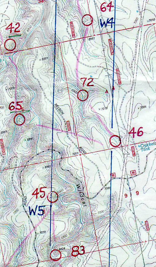
And... go! Just then John realized he had left the towline on his larger (nighttime) pack, so he ran back to get it. Ah well, what's an extra minute at the start of a 24-hour race? We got moving as I followed a bearing on the black-and-white orienteering map of the area near the start. I quickly determined that I had no idea what scale that map was, which created a slight issue but nothing too bad. Soon we hit our first point, #32 in a draw. We weren't even close to being the first team there. But we did see team iMOAT (Shaun and Jason), so apparently we had a similar strategy in mind for the beginning points.
We hoofed it down the draw and north on a small trail leading up toward #31. John decided to go up and over a spur on the more direct route - fine with me. We found the flag and jumped out to the south. Running down the road toward #53, we greeted some folks walking the other way.
The drop down to #53 was pretty significant, like all the topography in and around Chevelon Canyon. We hiked up a narrow spur to find #53, then started downclimbing toward the main drainage. Our course notes described this route as doable with a couple rocky drops. No problem, just slow. We wanted to cross the creek at the bottom without any detours, and that worked out fine.
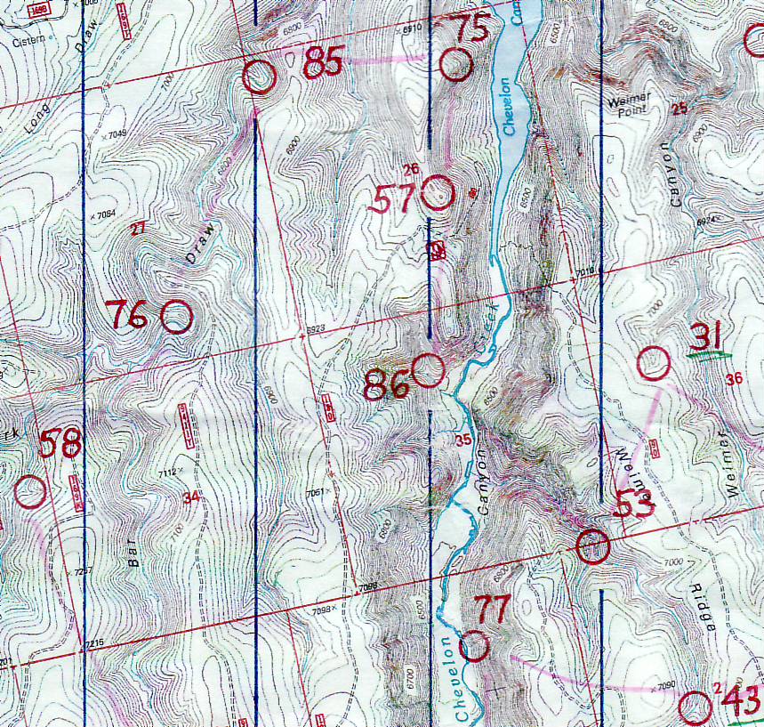
But my breathing limited my climbing speed up the draw. We didn't want to do too much towing, either, to keep from wearing John out, so he focused on mixing up our first portion of Spiz. We shared it, then ran on down and back up to #57 on a spur. A nice doubletrack trail led right up to it. We had been told that most ridges have off-road vehicle tracks across the top. We followed one toward #75 and then ran down a spur to the checkpoint. A team was coming up from the point and we greeted each other - they recognized my PQ hat.
The next checkpoint wasn't far away, just over a kilometer, but there was no way to avoid going way down into a steep drainage, way back up, and then way down again. Just get it over with. We weren't precisely sure of our location when we topped out, and we spent some time figuring that out based on the curves of the creek below us. Finally we got it. Descending again, we located the spur and point #85.
Going south, we followed some tracks along the creek for a ways. Eventually John realized that the tracks were courtesy of the local elk. Thank you elk! Instead of following a horseshoe bend, we climbed up and over a spur and down to point #76 in a saddle. The team just ahead of us followed the creek instead, and we beat them to the point. Now as long as we aren't using too much energy with the extra climbing, that could be a good move or perhaps not.
From there we continued south, up another climb and then over to a draw with #58 partway down. John started paying attention to the times recorded on the intention sheets by the other team in front of us, and he reported that we were losing a minute or 2 to them for every checkpoint. Just for reference, that's all.
We climbed up to a road and followed it for a bit, eventually jumping off and moving to a bearing/contour strategy. John was right on with his visualization of the terrain, also with his downhill running. I glanced at the map occasionally but mostly just tried to keep up. Nice work John, running us right down to #87.

I took over the nav to #79 at the end of a plateau, easy enough. We met a team walking the other way, always nice to have confirmation of your direction. From that checkpoint, we jumped down into a long, pretty draw leading gradually upward and southwest. It started with a great little trail and ended with a bunch of blown-down trees, so we climbed out early to avoid most of the mess.
We crossed a dirt road, down a spur, along a fence (John had the right idea not to cross it since we would just have to cross right back) and up to #59. That was the most southwesterly point, so that's something! Time to start working our way back north to finish this loop.
Coming back up out of the draw, we ran east along the top of it. John ran and I tried to keep up on the softer surface. The easterly run ended at a narrow spur and #89. We saw a couple other teams in this area. Now it was time to get down into the canyon. John had the good idea to follow the Telephone Ridge road to an actual trail that dropped into the canyon. Sounds great to me! Hmm, we might should have considered that road when we came south from #79 too.
The actual trail was not half bad. Probably much easier of a descent than many other options. It would have been even better if we had jumped off the trail and downclimbed a spur before the trail turned back into a side drainage and took us out of the way for a bit. Ah well. Going down we could see some racers over at point #88 - John yelled and waved but I don't know if they noticed.
At the bottom we found some people playing and splashing in the water. Hikers? Racers? Hard to say. John started heading their way but we found an easier creek crossing to the south. He led us along elk tracks and around to a side drainage where #78 was located. More running along the creek, then we approached #77 located on the side of a steep, steep reentrant.
One way or another, we would need to find a way up from that checkpoint. The drainage looked feasible but rocky and slow. John decided to try going up the area to the right. That was steep! I was really breathing hard from the higher altitude, even having to stop occasionally. Then John came across a little trail where someone or some animal(s) had made their way before us. That helped a lot.
I grabbed a tree without looking and then realized it was a burnt trunk. My right hand came away covered in soot. You may not realize this, but it's not easy to get soot off your skin. It didn't come off on my leg or on my shorts. I wondered if I would end up with soot marks on my face the next time I itched my nose. Hmm.
Partway up the hill we broke out the towline and made it to the top in short order. That necessitated a bit of recovery, which we did along a dirt road. We scared up an elk who looked like he didn't understand what was going on in the woods today. We'll be out of your way eventually, deer. John caught my attention when we needed to jump off the road again, and I helped him with the approach to the next point, #43.
One more climb, one more drainage to cross, then we were running up the road back to the hash house. Phew, that was a good loop! We beat our time estimate of 8 hours (taking about 6:45) but I was pretty salty from sweating in the relative heat. We noticed a big black cloud above and hoped we wouldn't have to deal with rain overnight.
We drank Ensures, refilled the bladders, and added all the nighttime gear. Now my pack weighed something, ugh. We checked out and started jogging north on the road. Another couple we passed commented on our running, such as it was. John claimed we only run the downhills. The guy's comment was that at the bottom of every downhill, there's another uphill!
Following trails most of the way, we approached #40. A group of adventure racers was hanging out near the point, and I heard one of them say "Orienteering sucks." They gave us encouragement when they heard we were doing the 24-hour course. Next we aimed at #71, with John taking a nice bearing and me helping again to locate the exact little reentrant to climb down.
Climbing up from #71, next we took a good bearing from the top of the next draw and came upon #51 without issue, this time being John's turn to correctly read the contours at the tops of the various draws. From here I lobbied to stay up top and take the long way to avoid some descent/climbing, while John suggested it wouldn't take much to go down and up. From #51 I looked down and agreed - it wasn't too far down and the climb back up wasn't too hard. I was definitely thankful that the largest climbs were mostly over.
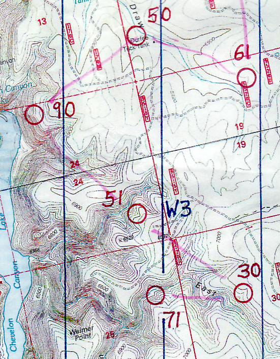
We hoped to get to #90 (one of two 90-pointers) while it was still light out, since it looked a bit tricky. So we booked it around toward the top of the canyon overlooking the lake. We did a nice job of getting into the right area, then we slowly worked our way down the terraces, looking for the steep dropoff to begin. Once there (and it was obvious), we turned south and found the spur within 100 meters. What an awesome point placement! We could see way, way down to Chevelon Canyon Lake, and to the west the sun was just going down. Spectacular. John remarked that the time he recorded on the intention sheet was 19:21, or exactly sunset. Sweet.
From there it was time to turn east toward some shallower areas. I wasn't sure if we would regret doing these at night, but hoped we could manage somehow. With daylight fading, we found a small road leading to a shallow drainage that led to #50. No problem there. I took over the nav for a bit, leading us along a gentle creekbed with good travel. I was pace counting and it seemed like it was going long, but I think I was just losing focus during my kilometer-long count. A side drainage to the left finally appeared, along with #61 and some bright orange and blue reflective tape that made it really easy to spot.
We aimed north for a road, and I expected to cross through the top of a draw along the way. When we hit a road, though, we hadn't gone through a draw. At least we hadn't felt it. I figured we had just missed it. I should have paid more attention to this as a clue. The road was easy to follow, however, and I really focused on an important pace count once it turned north. After 800 meters we jumped off to the east and walked right to #60. Phew, that one could have been a little difficult in the dark.
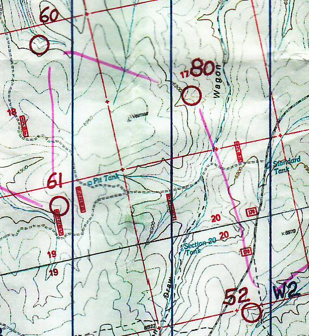
We turned slightly southward, looking for the top of our draw. Nothing much appeared out of the darkness, just flatness in front of us and too much vegetation to see any slight contours around us. We tried going south to find the edge of the "plateau" we were on. I think that's when we found an actual draw, so we followed it as it went sort of downhill, again ever-so-slightly.
When we hit a north-south dirt road, we got confused. Where are we? Still on the high area? Where is that 100-foot elevation drop we're looking for? We proceeded further east until it was obviously going UP, at which point I stopped suddenly as I realized I had the east-west part of the equation finally figured out. The dirt road was the bottom of Wagon Draw, and our point was west of that. Somehow we had made a descent without noticing. This is the problem with doing shallow areas at night!
Now the question remained: Were we too far north or too far south? We started exploring the little draws that seemed to go the right way but kept petering out. Finally, and this is perhaps an hour into our search, we decided we should start thinking about bailing. We turned south, and just to keep from totally giving up, John traveled a bit off the dirt road while I stayed on it to keep our position. The draw we sought might not be visible from the road.
Sure enough, eventually John called out uncertainly that he had a shallow draw, and I didn't see anything from the road to indicate it. I followed him up it, and voila! Point #80 appeared. We must have been farting around too far north where the contours are even shallower than in the southern area. How disappointing. But at least we found it.
Back on the map again, we followed roads out to the main dirt road and slowly rebuilt our momentum from scratch. We decided what the heck, we should go get #52 even though it was out of the way - travel to it was easy and quick. It was time for a Spiz, John was just out of water, and there were water jugs at #52, so we stopped for a couple minutes to fill things. We also started adding clothing - buff, gloves, poly pro. It wasn't too cold yet (and never got near freezing, which was a nice change from previous years), but there was no need to carry something on your back when you could be wearing it instead.
With that, it was time for another long-distance point. We guessed that there might be an ORV track going up a nearby ridge, so we followed a draw for a bit and then jumped up there. Yep, there's a nice road - cool. Curves in the road and contours that we could make out were easy enough to follow. Plus a bit of pace-counting to back it up.
Just as we were getting out of there, we saw bright lights above us. John called out "Ahoy!" and I almost asked what a hoy is exactly. Then we recognized the voices of Shaun and Jason from team iMOAT. Cool! We chatted for a minute and then left them to follow the spot we were coming from.
We headed back to the ridge trail and followed it north until it ran out. I was pretty sure we were close to the next checkpoint, so we went down and north into a draw. It turned south like expected (yay), at which point we looked up to see some large boulders in the area we needed to climb out. John found a way through with ease, and we could hear Shaun and Jason coming down the draw toward us.
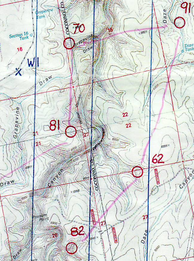
In the next draw we went west just a bit and located #70, greeting Shaun and Jason as we were coming back. Jason wasn't sounding too keen on the whole long-distance running idea, but they were moving just fine. We stopped to drink Spiz and then followed them along the draw. This draw was unlike many of the others from earlier in the day - no easy trail, lots of rocks and vegetation, slow going. I got a couple good scratches from this section, I believe.
Finally we all reached the main part of Wildcat Canyon. Shaun and Jason found the next draw to the north on the other side, while we decided to climb out of it and get out of the crap more quickly. The steep climbs were getting a bit harder on me. John took over the nav while I recovered. We followed his bearing, at which point Shaun's bright light seemed to show up from the left, which was a bit odd. Eventually it moved until it was directly where we were heading.
As we hit the next drainage, Shaun and Jason were coming down from a spot that looked like it could be the point. John stopped to check the map while I figured we should make use of the information in front of us - it just worked out that we were taking turns showing each other the point locations. Sure enough, there was #91. That had been my goal for that portion of the course - snag both 90-value points. Mission accomplished.
It was a long, long way to the next point and I was flagging a bit. Still, it was interesting to walk across a dry "tank" with earthen banks, and then we had a brief challenge figuring out the trails on the other side. I heard Shaun talking about needing to find one going southwest. Just then another team came walking toward us from the west. We greeted each other, then I suggested we should just go where they came from since it was an actual trail.
This didn't work, as the trail turned more northerly, and trying to understand the other team's actions was confusing so we decided to bail on both. We turned directly south, climbed over a short rise, and were soon in a nice drainage heading southwest on a small trail. Brightly-lit iMOAT was nowhere to be seen, so we figured they had moved on ahead and were long gone.
I led the way for a bit, going over and under logs here and there. I spotted a couple of small eyes staring our way, so I pointed them out to John. He trained the bright light on it, and it still stayed and stared. John wondered if it was a house cat? That would be odd! Finally it turned and left with a swoosh of a big tail. Perhaps a ringtail or a raccoon. I like to think it was a ringtail since I've never seen one in the wild. I also wondered how long that poor animal would be blinded before it got its night vision back!
Anyways, moving onward. We reached a flat open area that appeared to have a bunch of burned trees. I somehow managed to get soot on my hand again, leaving me walking with my hand stretched out trying to figure out how to clean it off. I spotted a bright light to the east and thought "What are Shaun and Jason doing way over there? Oh - that's the moon." On the bright side, there were a ton of stars out, so it looked like any signs of possible rain were gone. I tripped over some more downed limbs and tried to stay upright and focused. John found our drainage system and I followed him down and then up to #62.
John told me that Shaun might be messing with us because they hadn't signed the intention sheet. We climbed out of the draw and walked until we found a road that led almost to the next checkpoint. It would have been nice to run some of it, but it was generally uphill and we were generally tired. #82 was a ways down the next drainage but easy to locate.
Back up to the road, we looked for Fat Boy Tank as we walked, but we didn't find it. I sort of pace counted and watched for slight curves in the road. We were both dragging, especially with the uninteresting road travel. John took a guess on where to turn off for #64, my pseudo-pace counting seemed to back him up, and we found the top of the drainage but no side draw. Based on the angle of the drainage, John continued south and ran right into #64. Nice job!
Did I want to head back toward the hash house? We weren't super far away from it. But then we'd be giving up on the last two points on the east side of Wildcat Canyon. No, I said, let's at least head toward the next point or two and see what happens.
We climbed out of the drainage on the west side and followed a road a short ways south. My feet were surviving OK and I was pleasantly surprised when my legs reacted well to a request to speed-walk. So I didn't feel like we were in death-march mode just yet. We headed down the next drainage to a point that was thankfully closer than many of the previous ones. We punched #72 and I was game to finish this section by aiming for #46.
That involved following the drainage for a ways, not particularly slow or difficult going, and we made decent time. #46 popped into view, and then it was time to assess our plans for the remainder of the night.
Our original nighttime loop finished up with another 6 checkpoints - 2 60's and the rest 40 points or less. John was carrying the rest of the Spiz for the remainder of the 24 hours and he had been thinking all along that we might just want to stay out until the race ended at 11 a.m. The main reason to go back would have been to drop off lights and extra clothing - John offered to carry those (especially since our food would weigh much less by then), and he was going strong.
The most obvious reroute would involve collecting the last two 80-pointers and then working our way back. We bypassed #45 since it was up on the other side of the canyon and we didn't need the water there (although in retrospect this would have been a great one to detour to since we passed so close to it). Instead we aimed for #83 by first going south to the road. We heard a crackling nearby which spookily turned out to be from a large set of powerlines overhead. I was motivated not to stay in that area for very long. I looked up to see a shooting star - my wish was that my feet would stop hurting.
From a bend in the road we scrambled down into the canyon and followed elk tracks along the bottom. Thank you elk! It started to get light on the way to #83, and I was skeptical about how much more of the course we could cover based on our slow overnight speed. But for now we had time and my feet were still cooperating.
#83 was an easy find, then we continued on to greet a team coming the other way. We followed elk tracks further along the canyon, eventually climbing up a spur and OVER a little hilltop to go down to #74 in a saddle. Hmm, not sure if that was the most efficient route, but John is doing all the nav and thinking so the least I can do is try (try!) not to complain (too much).
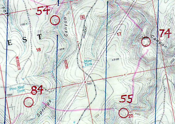
We climbed out of the Wildcat Canyon system for good, a big ascent with me on tow. There was a beautiful meadow at the top, my feet were going numb and no longer causing pain, it was warm enough to strip the nighttime clothing off, and things were looking up. We went a bit further north than necessary to get into the next drainage, then I misread the contours and passed up the side drainage we needed. We climbed a smaller version of a draw and ended up backtracking north to find #84. But at least we found it without wasting too much time. And we were done with the 80's!
Now we had to choose which way to go. We would need water soon, one more stop to get us through the morning. #45 lay to the northeast but I was having a hard time considering it since it was out of the way by now and worth only 40 points. There were two water depots to the west, but they required a long run on a road to get there, and I was also concerned with getting stuck on the south end of the map so far from the hash house.
John lobbied for going west, and I finally agreed that made the most sense. It turned out to be a really good decision, giving us a direct way home on the main road and a bunch of options for checkpoints along the way. But first, the hard part. We climbed up to the dirt road and started the long slog, about 3 kilometers with nothing to think about but my gratitude to my feet for not hurting any more. We alternated running/walking and made a bit of conversation, but mostly we quietly speed-walked and tried to get it over with as fast as possible.
We skipped #56 because it was out of the way and down a long hill. We saw a couple guys come out of the woods from that point heading toward the water stop, and we chatted with them for a couple minutes. They noticed the Eco-Challenge patch on John's pack and asked about it, telling us they had finished Eco-Challenge New Zealand. Cool!
John and I filled the bladders partway and then started hoofing it down the next road. It was downhill and fun to run on while watching contours. We headed offroad and found #69 lower down in a draw. That was the southernmost point! Time to start north for good.
Oops, first we have to get down this side of the canyon. It was pretty steep and John seemed to be following some tracks of really brave elk. Or maybe previous racers coming through here. I gradually got down as well, and we immediately started climbing up the other side. John towed me and soon we were looking at some large boulders. The clue was "spur, at the base of a cliff", and John almost called the location exactly right. Off by one little spur tentacle! #68 was in the bag and we had enjoyed finding it.
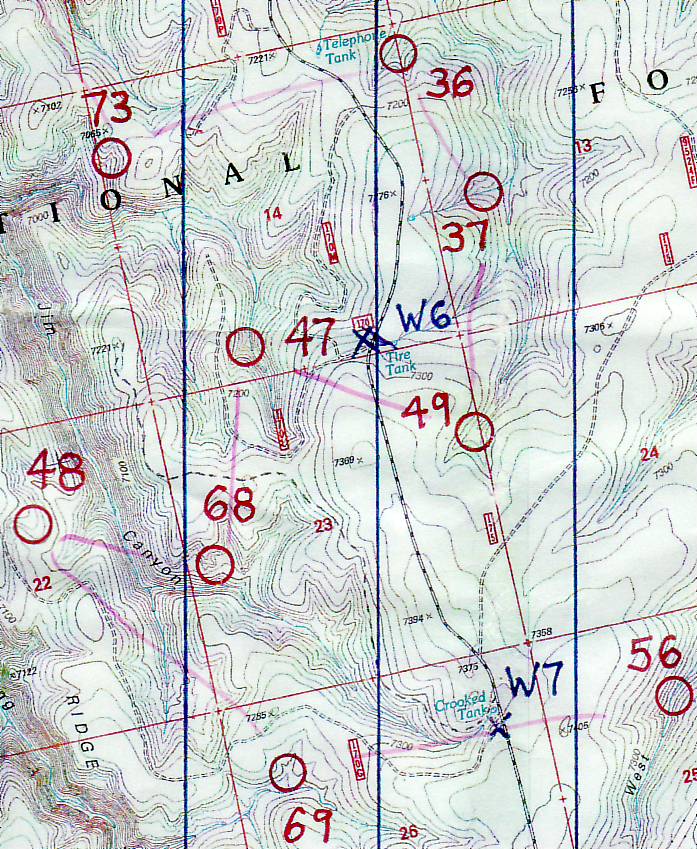
We skipped #47 in favor of a string of 3 points on the east side of the main road. I aimed us northeast, over a hill and the road, and then down a draw to #49. From there we contoured along a drainage, across one major side draw and over to the next one. I stopped us one draw too early but John decided it was too small for the contours. He took the low road, I took the high one, and I found #37 right where it was supposed to be.
I put us on a bearing over a small hill and down to the intersection of reentrants for #36. We met a couple other teams here, with one of them saying they were going to head back to the hash house and pick up #20 before finishing. I told John we still had time to try for #73, so let's get moving. I had the thought that we may not have been first to any of the points, but maybe we'll end up last at a couple of them.
Once we found our way around Telephone Tank, I was on the map and on a mission. We went back across the road, skirted a draw, and ran downhill/west toward a saddle. Once on a small road, I was pretty sure we were going the right way. John wasn't so sure, but I didn't want to take too much time to explain everything because the clock was ticking - it was after 10 a.m. and we were moving away from the finish line. Once I gathered that he didn't think I was going the WRONG way, I basically said "follow me" and led him to the top of two converging draws. And #73 at the draw intersection - yay! Hey, we got all of the 70's too, that's neat!
Time to head uphill and start back. The clock was looking good now, as we were moving a lot faster than a couple hours prior. My legs felt fine going uphill, and we continued to jog once we hit the main road. I compared the time to the map and decided we had the opportunity to detour to #34 on the way. John was fine with that. We ran past a team and checked the contours to our east before jumping down another drainage system.
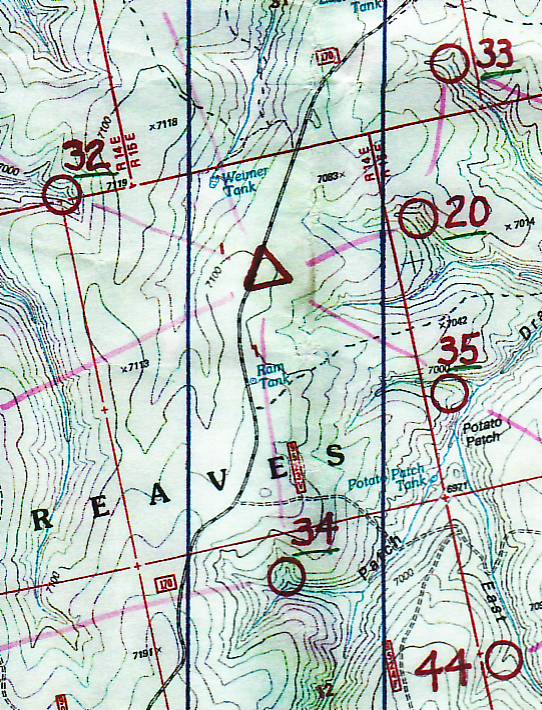
Only 20+ minutes and a kilometer left. I studied #20, so close to the hash house and yet, at about 900 meters past it, so far. With just a few extra or fewer minutes it would have been an easy choice. It just seemed so close to call, and really, we had been working hard all morning to finish strong and get as many points as we could. Surely 20 points wouldn't matter and we could just take it easy to the finish line? John agreed that this was fine with him. However, if either of us had said, "Let's go for it," I think the other could have been convinced.
But in the end, we walked it in with a few other teams. We turned in our card at 23 hours, 47 minutes, 44 seconds. As soon as we stopped, my feet took to hurting again. I sat in the shade and mumbled "ow, ow" while drinking Gookinaid. We hung out with Scott, Sheila, Jason, and Shaun, chatting about the course and how Shaun had NOT lost his pen - they had gotten themselves lost instead. Eventually iMOAT had come back to the hash house in the morning, finishing in 6th with a very respectible 2220 points. Scott and Sheila finished 2nd overall in the 12-hour category, and first in their category (co-ed masters).
When they hung the results for the overall win, I could not have been more surprised. First place team Verve finished with 2760 points. We ended up with 2750. Third place Platt & Poole had 2740, for a very close 1-2-3 finish. And those 20 points... would TOTALLY have mattered. Oh my heck. I walked around stunned by this news. For one less minor error, one bit of faster running in the dark, and of course for the lack of a major mess-up at #80, we were there. Wow. What a learning experience!
We ended up 2nd place overall, 1st place co-ed masters. Not world championship-worthy by any means, but enough to make us dream about the World Champs 2010 in New Zealand... we've been looking for an excuse to go to New Zealand! Hmm, how to make that happen? Must ponder.
Final analysis: Beautiful scenery, a wonderful place to run around in the woods for a weekend, excellent point placement and a challenging course by John Maier. Thank you!
Recovery has been going great, all sorts of scratches and bruises are healing, my legs feel good, and I think I've got some good motivation stored up for next time. Plus I got to watch the Survivor finale on Sunday night (didn't fall asleep once!), so life is good.
See some photos taken by Sheila pre and post race.