Aqua Terra Expedition 2007 Race Report
October 13-14, 2007Austin, TX
By Marcy Beard
|
John and I were psyched when we heard about the new Aqua Terra race, an Expedition version that is a 2-day paddling/running/navigation stage race near Austin. We like paddling, we love running and orienteering, we enjoy stage racing, and we were thrilled to get to do it all without traveling far from home. So we packed up our camp-around-Europe system (tent, sleeping bags and pads, little stove) into a big dry bag and headed for the race start at Lake Travis. We borrowed one of Kip's adventure race canoes (thanks Kip!), added a Vee-cart that we won in a drawing for signing up early, and we were ready to go. |
|
My biggest concern coming into the race was paddling on Lake Travis. It's a large lake that speedboats and water-skiers like to use, so we could face wind and big waves. Mike and Debbie, the race directors, indicated that we would have only one paddle leg on that lake before moving to Lake Austin down below. Speedboats and water-skiers like to use Lake Austin too, but at least the wind would be a much smaller factor, and getting to shore in case of problems would be much easier.
Wind was light and the lake was mostly clear of boats at 8 a.m. on Saturday, the start of the race. I was wishing we could just start paddling at that point, but no, first we had to complete an aerial rogaine around the Mansfield Dam Park. John and I took off with a crowd of racers towards the stairs at the edge of the water. Now that I think about, that's an odd place to put a set of stairs, leading steeply down to the water and stopping. Huh. After a bit of yelling and searching, John realized that Mike would certainly want us to get wet at some point, which helped him find the checkpoint under the stairs. |
|
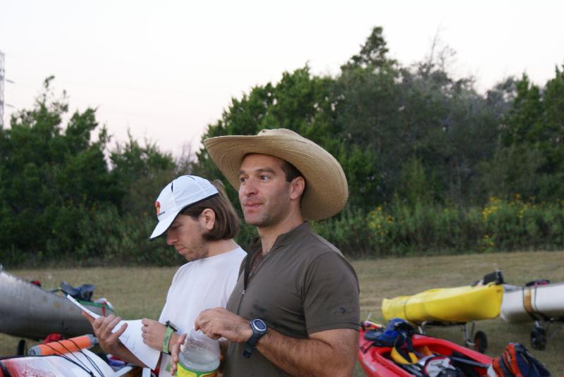
We hoofed it on tow out to a point, tried not to slide on the slick rocks, found a second CP, then ran around an inlet toward a third one. After a couple minutes of looking for the checkpoint, Kip showed up and led us to it (it helps that I understand some of the noises Kip makes when he's thinking). Thanks Kip! We ran with a bunch of teams across toward the main road and then down a steep sidewalk, down, down, to an old bridge over Lake Austin below the dam. The fourth and final CP was in a field, then the same mass of teams turned around and ran back to the TA to get our big maps and plot some points.
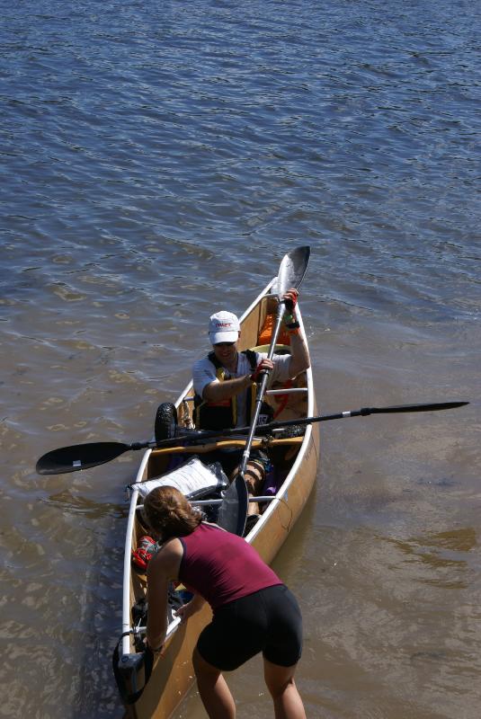
NOW it's time for the Lake Travis paddle. Still not many speedboats to be seen, and the wind and waves didn't look too bad. We started out dodging a couple swimmers (?), then headed out parallel to the dam. I figured we'd try for the points on the far shore first, then perform the "Lake Travis Traverse" on the way back. It might be easier to take a direct bearing back toward our last CP in that direction, plus I was hoping for a tailwind. One out of two ain't bad. |
|
First up, CP8 on shore across from the TA. It appeared as though the power plant station (or whatever it is) wasn't manned with an armed guard this morning, but we decided to avoid it nonetheless. I made a guess that we needed to go just to the left of it, and we ran head-on into the checkpoint. Yay for us.
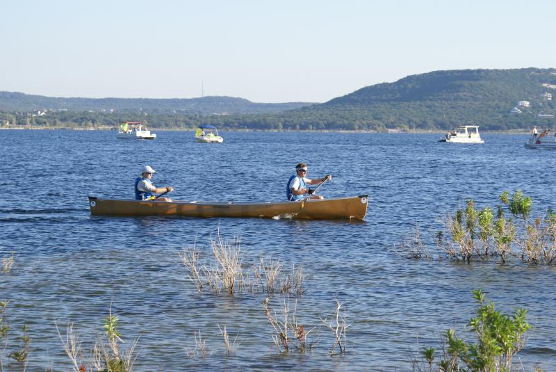
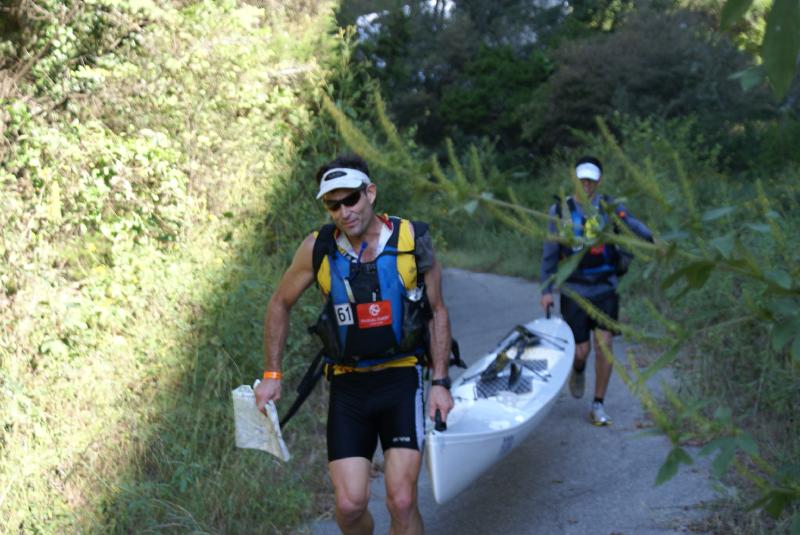
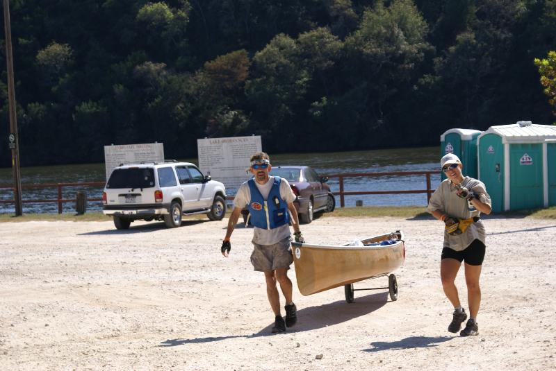
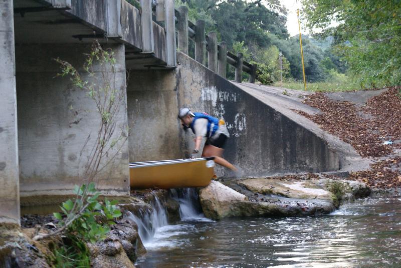
CP5 was up a big inlet with a bunch of sailboats moored to the docks. I made a guess that we should go between the boats, and we ran head-on into a dock. Oops for us. After a quick hop-out-and-lift-the-boat-over-the-dock, we were back on our way. We found the checkpoint and paddled back, this time taking the route along the north edge of the inlet to avoid the docks. We saw some other racers along the way, including Tom of Team Werewolves who appeared to be taking a morning swim (?). We found out later he had lost his glasses in the water, bummer. We exited the inlet and followed the shore along a bunch of pseudo-coves until we found CP6. Race boats were following us a little ways back, plus we saw other boats coming toward us from across the lake. Time for the traverse. The obviously-from-the-south (like the forecast predicted) wind was coming at us from the side, so it didn't make much difference wind-wise whether you got the points in a clockwise or CCW order. Hopefully we could make the most of the information in front of us to take a direct bearing, at least. So we paddled, battled the wind and chop, and discussed the topography ahead of us. A couple of buoys in the middle of the lake helped us see that we were indeed making progress even if it didn't always feel like it. Finally we could tell that we were aiming correctly, and finally we made the opposite shore and one last inlet. Up to CP7, punch, spin around, greet a couple teams right behind us, and head out to face a headwind for a short paddle to the take-out. As we came toward the park, Team MOAT was taking their boat out ahead of us. We felt pretty good about that, as they are excellent paddlers. The volunteer let us know that MOAT was in the lead and we were in second. We quickly hitched up our Vee-cart and jogged up the hill to the TA. We had been allowed to leave any non-required gear, including the big dry bag, at the TA for the Lake Travis paddle (thanks Mike and Debbie!), so we loaded it up now. With everything now in the boat, we headed back for the sidewalk under the main road that went down, down, down to Lake Austin. John and the cart handled the boat great, allowing me to drink a half-serving of SPIZ on the way. MOAT dropped their boat in the water (they were carrying it instead of using a cart - wow!) and took off, and as we were following after them we saw Kip and Jason running their boat across the bridge. Hey cool! |
| Dave and Julie had a boat cart problem on day 1: |
|
We knew we had a long and mostly-straight paddle in front of us to the next boat landing at Mary Quinlan Park. The main challenge was staying out of the hydrilla as much as possible (good luck with that) and hugging the right shore to reduce the wind in our face. So that kept me occupied on an otherwise event-less section. MOAT stayed ahead of us, Kip and Jason stayed behind us, and that's all there is to say.
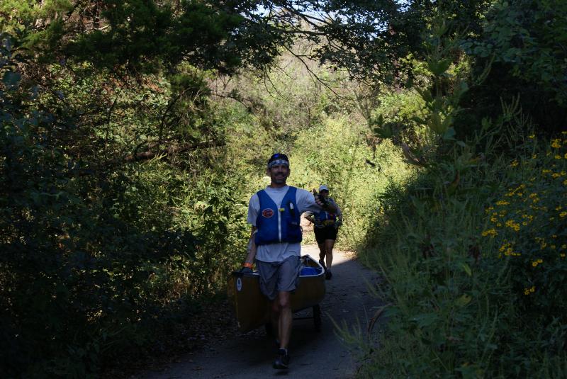
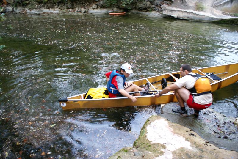
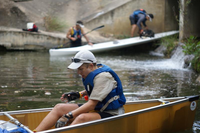
A while later we landed at the park. Well, actually, we tried to stop next to the edge, but some boat wake waves (where did those come from?) threatened to knock us against the rail. As soon as I could, I crawled out of the boat to dry land, got the passport from John, and let him push off. We were splitting up, but only because it was race rules. One person would run to the next park (Selma Hughes) and the other would paddle. We had been hoping to team up with Kip and Jason on this section, but we couldn't see them behind us and decided not to wait. We greeted Art and Ronda and their girls, then I jogged on up the road. I found CP9 at an intersection and ran down the next road. We did more downhill running on pavement in this race than we have in a long time. Passing a farmhouse, I heard barking and then a huge pack of scary-looking dogs came running out. Brief attempts at yelling, gesturing, and running away weren't working, so I grabbed a flimsy stick from the side of the road. The dogs turned around so fast, it was like they had hit an invisible fence. Cool. At Selma Hughes Park I found CP10 and briefly greeted Carlos from Team MOAT before Dave showed up to whisk him away. It seemed like I had some time, so I plotted the rest of our checkpoints on the picnic table. Kip showed up as I was finishing this task, and I told him we wished we could have teamed up on this section. Just as I said this, we looked up to see John and Jason together in one boat, towing the second one. Awesome! Apparently this solo paddle was really tough on John, so he waited for Jason to catch up. And Jason didn't seem to mind the company. Here's an example of what we faced on Lake Austin: |
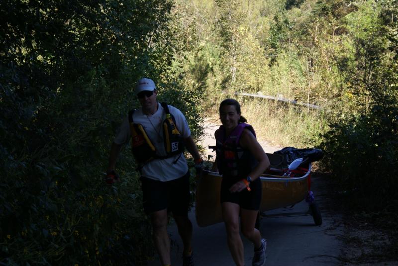
| Dave picking up Julie after their solo efforts: |
|
We unhooked the boats, climbed in, and paddled the short distance across to Commons Ford Park. The boat landing was a little ways up an inlet and under a low bridge. We tied up the canoe and jumped out to do some land navigation. Both of our teams decided to try for CP11, the closest point, first. It was listed as a mesquite grove. We had a bit of trouble with this one, starting with the bull nettle in the field on the way over (much cursing from me and Jason). Then we mucked around in the trees for a bit. Then we learned that my compass was reading 90 degrees off of north, so now it was useless. Finally we all hit "reset" and decided to regroup. Jason and Kip headed back toward the creek.
We had been asking John (the native Texan) what mesquite looks like, and he wasn't sure, but eventually he came to realize that we should be looking for more of a shrub in a field, not a tree in the woods. We found a couple of possible mesquite groves in the field and started searching. Finally we hit the CP - yay! We saw Kip and Jason exiting the woods and pointed them to it. John also gave some mesquite-type info to Curt and Garrett on our way out of the area. John worked on mixing up some SPIZ while I tried to come up with a strategy for the next 3 checkpoints. It was hard to think while pace counting and running. We ran into MOAT who was looking for the CP14 ravine. I decided to skip that CP for now and head for the furthest one, CP13. The creek trail stopped at a pretty waterfall and we followed some animal trails, at one point greeting Werewolves who I think were on their way back. An old fence marked the back boundary of the park where the checkpoint should be. We peered over the bank down to the creek, and as I tried to find a way to see better, John spotted the CP right under the branch I was standing on. Cool. We headed back on the animal trails. Here's where we messed up. It soon became apparent that we hadn't followed the same route back, and now we were too high above the creek. I decided that since we were up high anyway, we should try to hit CP12 on the side of the hill next. So we started a traverse that ended up being a climb all the way to the top of the hill to see where we were. Then we had to go around a big ditch system that was in our way. Finally we started downhill toward CP12, did a bit of searching, spotted Carlos walking downhill, and found the CP in the area he had just left. Thanks Carlos! That whole debacle cost us quite a bit of time. Back to the creek, we found MOAT in the same place we had left them much earlier, still looking for the ravine. We discuss the map and the topography, walked up the creek a little ways, and noticed a ravine to the left (they had been looking on the right side of the creek). Dave climbed up and spotted the checkpoint. They punched it and took off, while John and I were a bit slower getting back to the boats. Finally we were outta there, now in 5th place. Kip and Jason had departed in first, good show! Dave Bogle and Julie were also doing well, leaving right behind us. It was a long paddle over to Emma Long, but we never caught up to anyone and no one caught us. It was just us and the speedboats. Oh, and the interesting yard art and the inflatable woman. Shoulders tired. Neck tired. At least it was the last paddle of the day. Finally we landed at Emma Long Park, again timing our arrival with several large wake waves to make things interesting. Hi Debbie! We pulled the boat up to the TA, showed them a couple pieces of mandatory gear, and got ready for one last trek for the day. John prepped some SPIZ while I sat in some prickers while trying to clean out my shoes. Ouch! More cursing. |
|
We planned our route around an ascent of a cliff as opposed to a descent down it. It also seemed to give us an easy point to start off with. So we ran through the campground and along the trail at the edge of the water, just running along and not paying too much attention. We paid for that when the trail petered out and the checkpoint was nowhere to be found. It wasn't a definite trail-end like on the map, and I hadn't been successful in remembering my pace counting numbers.
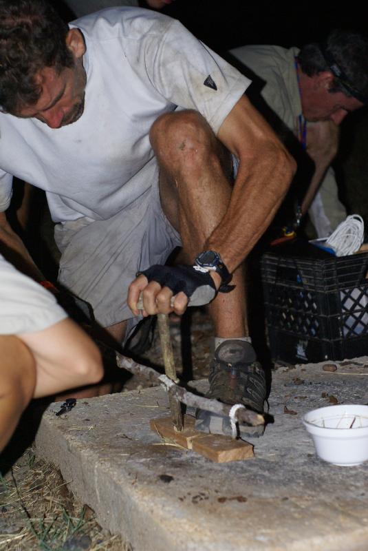
So we searched high and low, working our way back toward the actual trail, trying to decide what the clue "Cliff base" referred to. It was a steep slope to be crawling around on, and I was unhappy that we were losing more time. It seemed like forever, but we finally made it back to a pseudo-ravine and found CP15 partway up, just below some rocks. Arrgh. From there we had planned to go up and over to CP19 in Turkey Creek. It looked like a steep climb, but I wanted to try it. John helped me as we worked our way up. There was a false top, and then the most difficult set of rocks to clamber over. And we made it, yay! Great views of the lake from there. We paced-counted north along the cliff, then east toward the creek. We were a bit surprised by the drop-off into the creek and had to figure out a way down. I found a V-shaped crack down some rocks and that helped a lot. Once at the bottom I directed John towards the left, but called him back when I noticed the CP hanging from the back of a bush not 20 feet away. That was lucky. A trail led us out of the creek, then we carefully took a bearing to locate a huge gravel pit (good thing we were careful with that bearing) and CP20. We aimed back southwest to find the trail again and locate the drainage with CP21 in it. Here we ran into Curt and Garrett, then Dave and Julie. Plus a bunch of people with dogs. We took off running, quickly hit CP17 under a bridge and then slogged up a creek to CP16. One left! We jumped out to the road, cut across up the hill to the road on top, ran down the road to the water tower, and found CP18 in back. From there it was a quick run back to the TA via a convenient trail I decided to try. Amazingly, we were the third team in, with Curt and Garrett right behind us. Kip and Jason had been passed by MOAT in the final meters of the final leg, earning basically a tie score going into the second day. Exciting! The only bummer of the evening was finding out that Julie had hurt her foot, couldn't walk, and had to drop out. She and Dave went home that evening. I'm sure they weren't upset about missing 2 portages with a broken boat cart the next day, at least. Before the race started we had been given a set of instructions on how to build a fire using sticks. We were told to collect things to use in this endeavor, and in the evening we would participate in a special test to attempt to build fire, or at least get a flame going. During the Emma Long nav, John picked up a nice rock and a stick that might work. We had time after we finished running to recover, set up the tent, make some soup and noodles to eat, and collect more materials to prepare. Racers gathered around to watch Mike and Debbie demonstrate how it was actually possible to perform this feat. John decided to try it, and he created a bunch of smoke but couldn't keep the system going long enough to get any embers. Kip and Jason got even more smoke but also didn't succeed, nor did anyone else. Apparently it was pretty entertaining to watch, in any case. |
|
Finally we managed to get in a quick shower and collapse in the tent. It was a beautiful night that was over too soon. Before 5 a.m. I was awake and preparing for the second day of racing. Pretty much a reverse process from the night before, except without the hot meal or the attempt at fire creation.
We had everything back in the boat and were walking toward the beach when the boat suddenly landed on its side. One of the wheels from the boat cart had come off - how bizarre. We were actually pretty stunned. We searched the road and back to the grass but couldn't find the pin or the bushing that were needed to put everything back together. We were running out of time, so we slowly brought the boat down to the water, ran to the bathroom, and got ready just in time for the race to start. After a fairly non-violent mass start on the water, we got into a rhythm and followed a green glow stick ahead of us. Two boats took off faster than we could go, then there was Kip and Jason just ahead of us, and a boat with a monster headlight just behind. A couple fishing boats stirred up some wake, but for the most part it was a really peaceful morning. We paddled for about 3 miles to the bridge at 360, where we pulled the boat up onto the grass and received our checkpoint instructions for the day. We plotted the next 4 legs and then ran up to the pedestrian walkway to cross the 360 bridge. On the other side we located a trail leading up to an overlook where we found CP22. As we crossed back over the lake we saw MOAT and Kip and Jason running neck-and-neck toward us. From the boat landing we followed a road up and around toward CP23. At about the right spot in the semicircular shape of the road, we slowed and discussed where the checkpoint might be. I looked up to catch it in my headlamp beam, buried in a bush. Glad we didn't have to search too hard for that one. We booked it back to the boats, following MOAT onto the water and up an inlet across the way. We had seen this inlet on the map so many times before but never followed it, so it was nice to finally see it for real. Along the way we saw the neatest artwork, including a dog jumping through a flaming hoop. Then we passed the County Line and I wondered if they were serving breakfast tacos. At the bridge on 2222 we jumped out of the boat to hoist it up a small drop and carry it under the bridge to the takeout. There was a bit of a narrow opening through the trees to get to the road, so it took a few minutes but we managed OK. Then it was time for a portage. We put the boat cart on and walked with it slowly so the wheel wouldn't fall off. It was about a kilometer-long portage and while we wished we could run, we were really glad we weren't to the point where we had to carry the boat yet. |
|
Kip and Jason came running by with their working Vee-cart, hi guys! They were gone by the time we reached Bull Creek Park and the start of the next trek. John mixed up a SPIZ for me while I set about to formulate a plan. The word of the day was "methodical" and I didn't want to go rushing off without a decent strategy this time.
We aimed for the closest point first, CP24 in a ravine. John kept us on a good bearing as we followed trails to the base of the hill. When we got there, there was a ravine right in front of us. I debated spending some time verifying whether it was the right one, but it made more sense to check it out while we were there. When John called out that he could see the CP, I started laughing because it was just too weird that it was that easy. Score one for methodical, or maybe it was just luck. We followed trails over to a spur near 360 and started up the hill, searching carefully as we went. We got to a fence behind some houses at the top (or what looked like the top, although Mike told us later that there is more hill behind the houses). The next logical step seemed to be to move a few meters around the spur and start searching on the way back down. I found Carlos leaving CP25, so that worked out. We went down the hill with MOAT and jumped down to the creek to follow the trail under the main road. The next three checkpoints (a ravine, under the bridge, another ravine) didn't take much time. We ran to the far checkpoint and followed the creek up to find CP29 right off the trail, then turned and ran back along the creek. We chatted with MOAT along the way and passed Werewolves going in the other direction. Back at the boats, we used a picnic table to plot the rest of the points. Time for one final portage. We monkeyed with the cart, and John finally agreed to try using some wire from our repair kit to hold the wheel in place. Plus he realized he could turn the wheel around to expose the bushing on the other side. That worked, and now we could actually move pretty quickly down the road. Success! |
|
We took the boat back through the trees, under the bridge, and into the water, followed closely by MOAT. It was another long-ish paddle to the lake and down below Mount Bonnell. Long enough for MOAT to pass us. As we neared the inlet we were looking for, a speedboat appeared through the reeds, which seemed rather odd. MOAT took that channel and we decided it would be a good idea to do that as well. Nice little shortcut, thanks speedboat!
The next boat landing was at Mayfield Park, where we followed trails out to the roads and then up to Mount Bonnell. We found one CP at a dead-end road and then saw MOAT going the other way as we climbed the steps to the top of the "mountain" to get a date from the stone monument at the top. The very last digit was partly missing, so we decided the date was "July 15, 193u". Back down the steps, down the road, through the park, carefully taking the correct turns on the little trails to get back to the boat. I had dropped my sunglasses while getting out of the boat, but was lucky to find them again (underwater next to the shore) while getting back in. Always good to have reinforcement about the "cheap sunglasses for racing" rule. On the way out of the inlet we greeting Kip and Jason going the other way. Looks like they were solidly in third for the day. Plus we were starting to wonder if we could make up the 30+ minutes they had gained on us the day before. Didn't seem possible, but you never know. One last paddle leg - we took a direct line across the lake, practically daring any speedboats to get in our way. The last paddle CP was up a beautiful little moss-covered inlet. Then we paddled back across the lake and pulled up at the Walsh boat ramp. Yay! We started the last trek about 4 minutes behind MOAT, but with only street navigation ahead of us we knew we wouldn't catch them. We decided not to push too hard, but to keep running as much as we could. At Red Bud Isles Park we said "hi" to MOAT again, found a checkpoint on an island, and found the code word "CHAD" on the back of a Mutt Mitt dispenser. Then it was off toward the neighborhood to the north. We've run a few road races in that area, so I knew enough to try to minimize elevation gain and loss. We followed streets up to Reed Park and found a huge kiln there. After jotting down a date from the sign, we ran along a creek trail that popped out at an inlet by the lake. Neat little trail! There was one last CP that wasn't hard to find, then it was time to get to the finish line. I tried to take the street that paralleled Scenic, but the map failed me (and I cursed at it). John convinced me that we should just go up the hill on Scenic and I decided it would be easier to do that than to try to convince him to turn around. Good thing the extra couple of minutes wouldn't matter... Finally we were running down streets back to the boat landing and we were done! Eight minutes behind MOAT for the day, first place co-ed. We hung out and drank sodas (thanks Debbie and Mike!) and chatted while I did calculations and then counted down the time that Kip and Jason had to arrive by in order to beat us in the overall standings. Six minutes past that time, they came running in. That sure was close! We were second overall behind MOAT, with Kip and Jason in third. We had a really good time and especially enjoyed seeing parts of nearby parks that we had never seen before. Mike and Debbie put on a great race and I highly recommend participating in as many as you can!
|
Route Mapper tracking of some of the teams at this race
(8 of the 19 teams volunteered to carry GPS trackers along with them as they raced... our teams did not)