Too Cool "Somerville Sprint" 2007 Race Report
March 3, 2007Somerville, Texas
by Kipley Fiebig
|
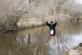
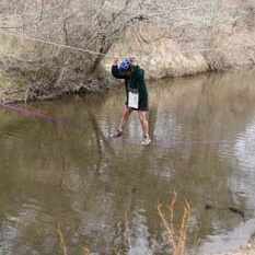
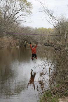
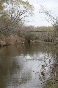
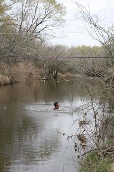
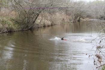
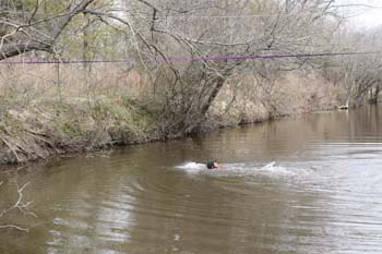
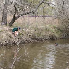
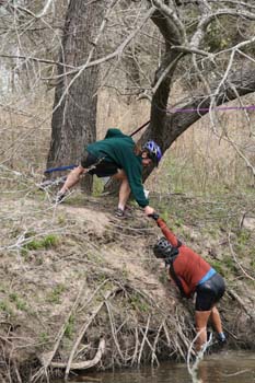
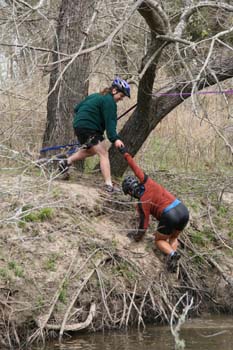
This year Too Cool Racing introduced a new series of "sprint" races, which are shorter than their usual day-long events. This provides an opportunity for new racers to get into adventure racing at a level that's not quite so intimidating. I decided that it would be fun to race the series with new partners, so I posted a notice saying that I'd partner up with anyone who would take me. Tina Burgos claimed me as her teammate for Lake Somerville. She's no newbie, as she usually races with Team Peanut Butter. She also owns a nice kayak, which is a lot heavier than my Kevlar canoe, but also much more stable on windy lakes. The weather forecast suggested that the kayak was the right choice for this one, as the winds would be picking up to 18 miles an hour, and Lake Somerville is large enough to allow huge waves to build up. A half an hour before the start, we were handed the coordinates for all the race checkpoints. During "normal" races, the coordinates are handed out at the start of each leg, so you have to plot them while the clock is running. But since the sprints were designed to be friendly to new racers, we got to plot and plan our course without worrying about how long we were taking. Since the first three plotted points were on the lake, it was pretty obvious that we'd be starting with a paddle leg. So we went ahead and prepared for it, by stowing our packs in the boat, and wearing our life jackets to the starting line. However, Art and Robyn (the race directors) had a surprise for us at the start... before we'd get around to finding the points we'd just plotted on our topo maps, we would first have to trek to find five points that they'd pre-plotted for us on an aerial map of the park. It would be a short, easy leg, but it allowed the teams to spread out a bit before we all went to launch our boats in the water. Tina and I decided to just go ahead and run this part with our lifejackets on, as they were helping to keep us warm in the cold morning air anyways. And with that, the directors yelled "go!", and all 26 two-person teams took off running. The aerial points were easy enough to find, as most of them were located just off the main park roads. It was fun running around, watching all the other teams trying to find the same points, but choosing to do them in different orders. We were able to cut off some distance on the return trip by taking a shortcut on a trail instead of sticking to the roads. We got back to the transition with a group of other teams, in about 5th-7th place, and grabbed the instructions for the next leg. As expected, it was now time to paddle across the lake. Since we already had our life jackets on and our boat rigged, we were able to launch more quickly than most teams, and we were soon paddling across the lake tied for the lead with Carlos and Lisa of Team MOAT. MOAT's boat was faster than ours, but a bit less stable. As we left the shoreline and started hitting the bigger waves, this fact caught up with them, as suddenly MOAT's boat was overturned, and Carlos and Lisa were swimming next to it. Fortunately we were right behind them at the time, so we were able to pull alongside them, and stabilize their boat while they climbed back in. Then we decided to be extra friendly by chasing down one of their paddles that was floating away, as they would have had a tough time catching up to it with just one person paddling in those waves. Once that good deed was done, we were back on course. The first checkpoint was on a little island. We were in a group of about four boats that all docked and got the point within about a minute of each other. The second point was a bit harder to find, as it was hidden in one of several inlets along the far shoreline, but the lead boats used a "group think" location averaging method to hone us in on the right location. After that point, it was time to turn around and head back across the lake. This was a most welcome relief, as for a short stretch the wind and waves were actually pushing us in the direction we wanted to go. It felt like we were surfing. Unfortunately, around this time team MOAT capsized their boat again! I'll bet they wished they'd brought a more stable watercraft for this windy lake. Well, since we were still the closest other boat to them, we once again helped them out and assisted them in getting back upright. At least they didn't lose a paddle this time. We made it to the final paddling point on another island, and then headed back to the transition. It was getting a bit tiring fighting the waves, but Tina is a great paddler, and her ruddering skills helped keep our boat facing in the right direction. We docked and pulled up the boat seventy-five minutes after putting in, soaked but fortunately not too cold. Despite the time we spent on the water rescues, we were still in fourth place at this point, with the lead team only two minutes ahead of us. We quickly ditched some of our wet clothes and jumped onto our bikes, passing two other teams in transition in the process. We hit the bike trail and started chasing down the leaders. There were patches of sand on the trail that slowed me down, as my tires were too skinny to fight through sand. But these parts didn't slow down Tina at all, so I struggled to keep up with her until the trail became more solid. We hit the first biking checkpoint to discover that there was a special test setup there: There were ropes setup over the creek we'd need to cross. Two cables were tied across the creek, one low for you to stand on, and one high for you to hold onto. The volunteers at this section told us we had to make it over on the ropes, punch the checkpoint, then run a short ways up the creek and cross back over the bridge to return to our bikes. Fun stuff! I went first, and found this test to be a bit tricky, as you tended to wobble back and forth due to the ropes being slack. But, I hung on and managed to make it to the end. Tina went next, but her feet slipped off the rope at one point. She hung on with her hands for a bit, but it was obvious that there wasn't really any good way to get her feet back on the rope, so she fell into the creek. She was about to climb out and try again, when the volunteer told her she could just swim instead if she wanted. No problem! She quickly swam across and we then jogged back around to get back to our bikes.
|
 |
 |
 |
 |
 |
 |
 |
 |
 |
 |
|
We caught up to the lead team, Texas DARE, on the bikes soon after that. For the rest of the bike leg we pretty much took turns trading the lead with them. The second bike point was in a bird watching hut that overlooked Flag Pond. We continued on the trail around the pond to the third point, which was located beside a huge culvert. Then it was a matter of biking around the rest of the pond, and backtracking our way on the trails to return to the start. At one point, I thought we had left Team Texas DARE behind, but they caught up to us again when I got slowed down by the sandy sections near the trailhead. So, our two teams wound up finishing the bike section essentially even. So, the race would all come down to the final trekking leg. This leg involved some real navigation... not terribly tricky, but not trivial, either. We had to run around the park to find the five points in any order we wanted. Texas DARE took off first, and it looked like they were going to collect the points in a counter-clockwise order. So I decided we'd chart our own course, and go clockwise. But, no sooner had we started that way when they changed their direction, so it turned out that we were once again traveling with them. They were nice enough folks, quite friendly, actually, but that didn't change the fact that we wanted to lose them! Our route to the first point followed around the shoreline to a peninsula tip. At first it looked like we'd be able to follow a makeshift path the entire way, but the path died out just below the tip. Our two teams looked around for a good way up, but there was some nasty vegetation in the way. Eventually Texas DARE decided to stay low and head further around the shore to find a clearer way up. Tina and I decided to just go for it, and push our way straight up though the trees and brambles. If you race in Texas much at all, you get used to fighting your way through crap. Fortunately, it only took us a couple minutes worth of bushwhacking to climb up, and when we broke through to the clearing at the top, sure enough, there was the checkpoint. We quickly punched it and ran back out of there as quietly as we could, hoping that the other team hadn't heard us. A nice trail led out of there, and took us most of the way to our second point. This one was along the shoreline, and we could see where we figured it would be long before we actually go there. We punched it, and then turned around to head out to the third, and farthest trekking point. As we were running back along the shore, we ran into another team heading to the second point... but it wasn't Team Texas DARE, instead, it was Team MOAT, who we hadn't seen since finishing the paddle. How'd they catch up to us? Drat, guess this means we can't stop running just yet...! So we keep running the long distance to the third, farthest out point. Since the route was mostly along the lake shore, we could monitor how far behind Team MOAT was. Unfortunately, they were gradually gaining on us. Not much we could do but hope that we could out-navigate them! They caught up to us as we were leaving the shore to follow a river up to the point. Then, they told us the surprising good news: They'd started getting the trekking points in a bad order, and hadn't visited the first point that we'd already gotten. So, they would still have to double-back to get that point before finishing. Well, that was comforting! Perhaps we could hold onto our slim lead after all! Both our teams ran up the winding river, looking for the point. MOAT got there slightly ahead of us, so we got to follow them right to it. To get to the next point we had to make our way north to a fenceline, but there was more vegetation in the way. Our two teams spread out a bit, trying different tiny trails that kept dead-ending. We wound up taking different routes through the mess, but still got to the next point on the hilltop almost at the same time. We knew that our final point would be on a major trail, but we had to wander again through a maze of smaller trails to find our way to it. None of these trails were on the map, but we just kept heading generally northeast figuring that we'd eventually run into it. Sure enough, there it was, and once again MOAT was there just ahead of us to show us the point. Thanks, guys! From here, it was just a quick jog back to the start. We were so glad that MOAT had another point to pick up, because they were still ahead of us and moving faster, so we wouldn't have been able to out-sprint them. We headed in, quite happy that we'd managed to finish first overall, after 3 hours and 32 minutes of racing. MOAT finished 8 minutes later, with Team HART Double Daves right behind them. Team Texas Dare, who we'd shared the lead with for the entire biking leg, finished 5 minutes after that... they'd had a lot of problems when it came to finding their way up to the first trekking point. So, it was a very fun race, with a lot of good friendly competition along the way to keep us motivated. Tina was great to race with, always upbeat and ready to chase down the competition. There were a lot of unfamiliar faces at the event, so it seems like this sprint series is successfully luring a lot of new racers into our wacky sport. Excellent! |